 |
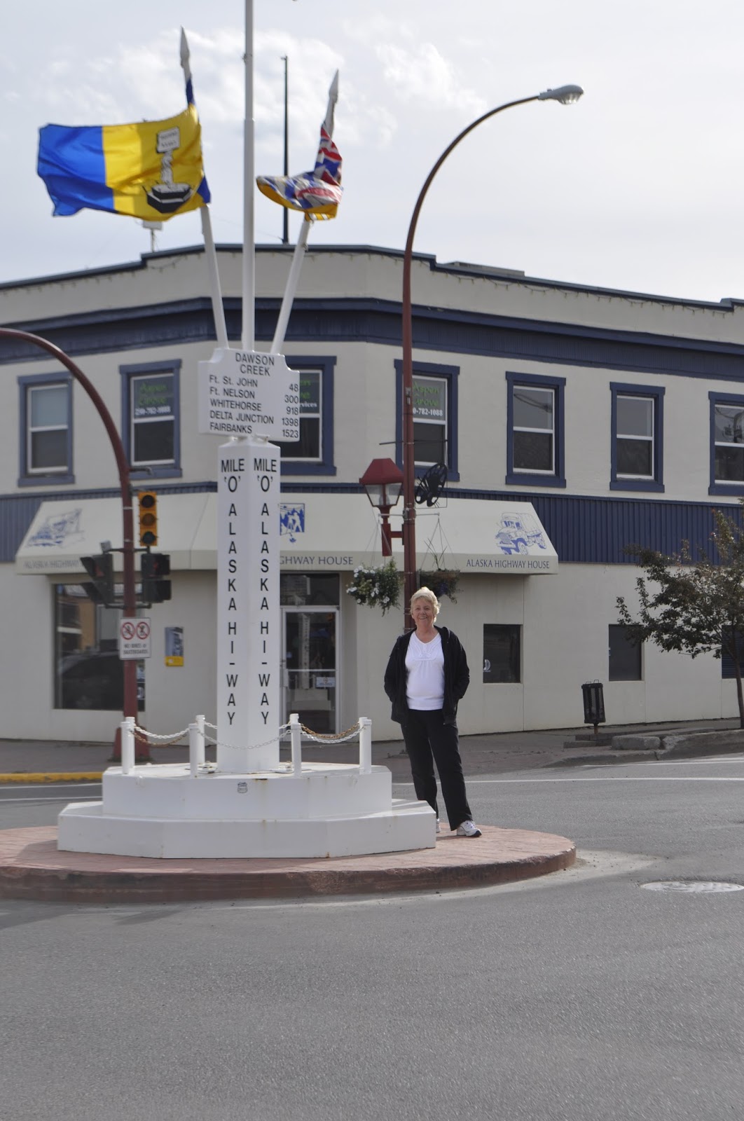
| Original Milepost Zero Monument, downtown Dawson's Creek |
On the Alaskan Highway at last. After months of planning, working, rearranging schedules, we are actually here with our tires on this fabled highway. It seems magical and at the same time, oddly prosaic. After all, its just a two lane highway through pine trees. Hang onto that thought...a two lane highway through pine trees. It's a recurring theme for the next, say, thousand miles. However, all you have to do is look out the side window to realize that this highway is a very narrow corridor through an incredible wilderness that ends at the Bearing Sea.
The highway is surprisingly good. Much of it is as good as the roads around home and better than some. There have been the occasional construction sites that cause delays and an occasional really rough spot in the pavement. The speed limit is about 65 mph much of the way, but the Canadians never miss an opportunity to drop the speed limit 20 kph for anything along the side of the road. They do have a lot of bridges over rivers that are a bazillion feet below you when you are on the bridge. Many of these have steel mesh decks which make the RV squirrel around as it travels. The really interesting bridges are those with no shoulder and all the support structure below the bridge. A flat surface hanging in mid air with a few feet of lightweight guard rail. That will slow you down in a hurry as the rail disappears from view alongside the RV! See Pat scream!
But, you cannot travel this road without feeling its history. We have nice summer days with temperatures suitable for short-sleeved shirts and cool nights that are great for sleeping. Winters must really be something else. The low temperatures can reach -70F, a temperature that makes steel so brittle that it snaps. Eight feet of snow is a light snow cover, yet they keep the highway open.
The highway was begun as a joint Canadian, US military effort after Pearl Harbor forced people to reconsider the vulnerability of North America. Back then, Dawson Creek, BC was the end of the line; railroad that is. It was a small agricultural community. In 1942 the highway was begun there and finished in 1943 after 8 months and 12 days. In that time 27000 people built 1523 miles of highway, 133 bridges, some of which were washed out multiple times, and put in 8000 culverts. There were 7000 pieces of equipment that could not be shut down in the winter because they would not restart. In the summer, mosquitoes and black flies were so bad that people wore netting all the time. Bridges were built of wooden beams and only one of them is left standing.
We traveled from Dawson Creek, BC to Fort Nelson the first day on the highway. stopping to spend the night at the Triple G Hideaway, a colorful place and a nice evening. The next day we traveled to Watson's Lake, climbing over the Rockies again and re-crossing the continental divide. A good bit of this road was slow going over mountain passes and up steep grades. It's a shame to say, but you can become immune to the endless beauty of this place...look another beautiful blue lake against a snow capped mountain. We ate lunch at a turn out off the road at Muncho Lake (yeah, yeah no pun intended). PHOTO
We crossed into the Yukon Territory late in the afternoon. The Yukon! shades of all the stories and poems that I have read in school or for fun! Aha, a two lane highway between the pine trees (or more accurately spruce trees with some pines). At Watson's Lake we stayed at a less than beautiful RV park, imagine a gravel pit with rvs parked as closely as possible, but we slept. Should you ever get there, they have a planetarium there where they show you what the northern lights are all about. That is so definitely worth it. We learned a lot and saw light displays that were the result of a year of travel all over the world to places above the artic circle. Imagine filming in those -50 to -70F temperatures.
Leaving Watson's Lake we traveled to Whitehorse, YT. Another fabled place. The last gold rush came up from Fairbanks, Alaska on the Pacific coast and traveled up the Yukon River to get to Dawson City and the gold fields. The hallmark of this part of the trip is the amazing mountain lakes that go for miles and miles. Not just one of them, but you no sooner clear one than in a few minutes you are looking at another. There is so much water up here that I cannot believe that people have fished all of it. We crossed over so many beautiful streams and small rivers, each of which could have provided fishing for days.
The last several days have been long drives between distant towns over the type of road that keeps you busy driving. So we are taking a couple of days off in Whitehorse.
No comments:
Post a Comment