Sunday, June 21, 2015

Now for the fish part

This is a continuation of the previous post about our adventures in Valdez, AK.  The day after eagle watching, I went halibut fishing, something I have never done before.  It turned out to be an exciting day.  There were six of us on the boat, a husband and wife along with her father, myself, another guy, and a woman whose husband couldn't come fishing.  We left at 6 in the morning and got back about 7 that evening.  It was a three hour trip each way to get to the fishing grounds, a distance of about 90 miles.  I was not able to take pictures on the boat, it was too busy and crowded.  The scenery was very enjoyable and I wish I had some pictures.  The mountains stop at the waterside and are a combination of rocky outcroppings and forested slopes interspersed with waterfalls and glaciers.

Critter watching was fruitful, too.  We saw seals and otters (really laying on their backs in the water with rocks to crack shellfish open).  We also saw porpoise and a whale.

We sailed on the Jenny Linn, with Chris as our captain.  We had a lightly overcast day with little wind.  As a result the temperatures were cool and there was no risk of sunburn.  The water was smooth, so there was no rocking and rolling.  All this made for really fine fishing.

We began by fishing for rockfish along a rocky ledge. You are allowed to keep a combination of rockfish species up to four.  There are black bass , red snapper, and a fish called a yelloweye.   I was able to catch four black bass and also caught a big halibut, approximately 60 pounds.  That is a huge fish to reel in!  That nearly completed my limit for the day by 10:30 in the morning.  The others also caught their limit of rockfish.  We moved to deeper waters and continued fishing for halibut.  I was allowed one more halibut under 29 inches long.  Naturally the ones I hooked had to be released because they were too big.  However, fishing slowed way down as fishing will do and we spent several hours fishless.  Then shortly before it was time to go, we began to catch a few.  I finally got my last halibut and the fellow who had released a moderate sized fish and was looking at going home empty handed caught the largest fish of the day, about 90 pounds.  Now, a 90 pound fish will really fill up a boat, especially when he is unhappy and flopping all over the place.   That guy also caught a skate which we released right away without removing from the water.  No one wanted to argue with a four foot long ray.

A happy fishing trip
We got back to the dock at 7 pm and began to unload and clean fish.  They have people to help you get things done.  A fish cutter cleans and fillets your fish for you and a place that will package and flash freeze your fish is right up the street.   The fish cutter was fun to talk to and fascinating to watch.  That man could fillet a fish in no time flat.  As he was doing my fish, he told me about the life of a halibut.   They are born 200 feet deep in the ocean and swim upright like any fish does for the fist two months of their lives.  Then over a period of a few weeks to a couple of months, one eye migrates across the top of their heads until both eyes are on one side of the fish.  They then begin to swim flat like a flounder, to which they are related.  They are a very aggressive fish and can weigh as much as 150 to 180 pounds.

When it was said and done, I ended up with 50 pounds of black bass and halibut fillets.  That's a lot of fish.  Unfortunately, I was not able to take any pictures because the boat deck was too high when you were in the cabin and when you were on deck, you were busy fishing or getting out of the way.

On the way back in to the harbor, we passed an oil tanker heading out to sea.  Valdez is the end of the trans-Alaska pipeline (more info and pictures), a really amazing thing.  One of the people on the boat worked in the oil fields and he described how the get the tankers out of Valdez after what happened to the Exxon Valdez.  So, you have a giant oil tanker steaming down the center of the waterway.  It takes miles to stop the thing and huge distances to turn it.  The waterway is large, but not that large.  Behind the tanker is a red tug boat connected by a cable to the tanker's stern.  This is the power tug and it is connected backwards.  That is, the stern of the tug boat faces the stern of the tanker.  Way behind the red tugboat is a yellow tugboat connected with its bow facing the red tugboat's bow.  This is the steering tugboat.  If something goes wrong, the red tugboat has huge engines that can slow or stop the tanker.  If they need to change direction quickly, the yellow tugboat has a special propeller that can turn all the way around and face in any direction.  It drags the tanker sideways. 

So all this was going along with the engines of all three running.  It was an amazing parade.  When the oil tanker gets out to the entrance to Prince William Sound, it disconnects from the tugs and goes on out to sea.  Wow, I wonder what it costs to take a shipload of oil to the Pacific Ocean.

Another interesting tidbit.  You may remember from your history that Captain Cook originally explored this area in 1778 (more info).  Well he had a lieutenant named Bligh, who later became the famous Captain Bligh of the Bounty (remember the Mutiny on the Bounty?).  Bligh managed to run a ship aground on the shoals at the mouth of the inlet where Valdez is today.  They were named the Bligh reef and the island next to them was named Bligh Island.  That is where the Exxon Valdez ran aground.  Our fishing trip went between Bligh Island and the mainland down to Port Fildago.  Here is a map that shows all this.  So since I didn't take pictures, you get a lot of links.  I hope you enjoy this little lesson about Alaska. 

Eagles and Fish

Valdez, Alaska

Valdez Small Boat Harbor
This has been a lot of fun, here.  It's a small town full of really nice people, surrounded by mountains with one road in or out.  There is also a ferry to the rest of the world.  We are staying in the Frontier RV park that is a stone's throw from the waterfront.  There is a port there that had a big cargo ship tied up there the other day.  They have two fish canneries there, also.  Fish is a big deal here.  The Copper river enters the sea here and there are three types of salmon, rockfish and halibut to be caught.  The mountains come right into town and right down to the water. 

Calling the eagles


It turns out that in the rv park across the street from us, they feed the bald eagles each day at 5pm.  So, we strolled over there dragging the camera along.  WOW!  A fellow brought a bucket of fish out to the parking lot and stood about 15 feet from the group of people wanting to watch.  He held fish up in the air until the eagles saw them and began to circle.  He threw the fish on the ground no more than 20 feet from us.  The eagles would circle, dive on the fish, grab it, and climb back into the sky.  What a photo op...I took about 100 pictures.  Now the rest of the blog is pictures of eagles....no I won't  do that to you.  But here are some of the ones I liked.  Since there are so many pictures, the fish story will have to be another post.


The small bird on the ground is an immature eagle

Young eagle taking off


Approaching fish from a glide, some dove straight down


On the way to Valdez, AK

We left Tok this morning after a good nights rest in a pleasant grove of trees.  We traveled more rough road.  This time so much so that we only made 160 miles and quit after 5 hours of driving.  We are in Glennallen, AD, where the road divides between Valdez and Anchorage.  When we stopped and I started hooking up the utilities, I found that the cable from the coach to the truck that actuates the truck brakes had broken.  So, no brakes on the tow.  That meant a trip to the local hardware store for cable and fittings and a kluge to get it back together.  We'll see how well it works when we leave this morning.

32 wheels! count 'em
For the truck guys:  They are really serious about their trucks up here.   I first noticed that when I was passed by a behemoth with 26 wheels and a trailer longer than the rv.  Then while we were eating dinner in Watson's Lake, these two rigs pulled in and their drivers came in to eat dinner.  I snuck out and took this picture.  Thirty two wheels...wouldn't you like to be a tire store when these guys showed up.   A whole month's sales on one vehicle.


Valdez, Alaska.

We made it to Valdez over mostly reasonable roads through more amazing mountains.  The mountain ranges in Alaska seem to run from the center of the state on the Canadian border to the coast north of Anchorage.  There is a second large range that runs up the coast from Vancouver, BC north.  Valdez sits in an inlet off the Prince William sound.  This got to be the only town sitting at sea level with mountains so high that the clouds cover the peaks.  Come to think of it, Vancouver is similar. 

As you go south from Glennallen, you pass alongside the west edge of the Wrangell-St. Elias National Park.  The sign above shows the mountains and here is a picture of Drum Mountain.  I am standing on the west side of the  Copper river valley.   The Copper river you see in the lower right runs along the valley floor at my feet before curving to the east.  (By the way, this is my only moose picture so far.  He's in there if you look really hard.)  This is a very famous salmon fishery and Copper river red salmon are highly prized.  This is the territory of the Ahtna people and are several spots where First Nation people have set up fish wheels  (link will tell you about them.)  I will try to get pictures of the wheels as we visit the river valley later.

We arrived in Valdez after coming over the Richardson pass, another example of how going north really changes the relationship between altitude and the environment in a given area.  The pass is approx. 2600 feet high, but the climate is that of country 12000 feet high in Colorado or New Mexico.  The top of the pass is a splendid view that seemed to take all the traffic into the parking lot just as fast as it arrived.

Panoramic view of Richardson Pass summit


You leave the summit and come down the pass dropping the whole 2600 feet in one long grade.  It's 22 miles from the city limits to the center of town.   Along the way, you are treated to a series of waterfalls such as this one. 


As you reach town, you find an arm of the Prince William Sound with the town nestled in the mountains on the shore.

Thursday, June 18, 2015

Atlastalaska


Oh how long I have waited to  post that title.  We finally made it.  We can attest to the fact that there is a land bridge from the lower US and Alaska.  It's called Canada and its a really big place.


Waiting for the follow me
Well, the Alaska Highway is what people say it is.  It is reasonably good road, although after driving all day, one is sick of the vibration and bouncing around.  A few days of this makes you wish for a smooth road.  Worse yet is the highway (de)construction.  For example, it took us an hour to go 26 km the other day with a "follow me" truck leading us in a convoy.  In front of it was another truck dumping water on the road.  The stop light in the middle of nowhere was rather spectacular.  But all the steps of highway (de)construction go on at once in all the lanes, so the convoy is probably a good idea.  By the way, there was as much traffic behind us as in front of us.


No longer a white truck...doesn't do it justice
Apparently they finally give up on patching and just reduce everything to a rock base.  Then they  add water and roll it and add water and roll it until they get tired.  Finally, they oil it and roll a layer of rock onto the oil.  Meanwhile, what a muddy mess. 

However, after we left Destruction Bay, the highway earned its reputation.

WE GOT THE HEAVES

The frost heaves, that is.  By this time we have gotten far enough north that the ground is permanently frozen except near the surface, i.e. permafrost.  As a result, the road suffers frost heaving.  That takes a normal road and converts it to a roller coaster ride with subsided parts of pavement that are deep enough to bottom out the suspension.  Added to that is pavement twisting that results in a ride just like a small boat in a stormy ocean.  NOT FUN!  Even at 20 mph, the road is so rough that it feels like you are going to shake the rv apart.  The best part is that you often cannot see the flaws in the road in front of you.  The road looks normal.  I found the best sign of impending trouble was the sets of skid marks in the bottom of a dip!  If you were lucky, this was enough warning to get slowed down somewhat.  Note that the USS RV neither slows down or speeds up quickly.  This does not happen continuously, just in stretches, usually you get to a new one just about the time you have gotten your speed regulated again from the last one.

Add this to mountain passes and it takes all day to go 230 miles.  Tok, Alaska was a very welcome sight indeed.  We spent two hours washing the rv and the truck, went out to dinner and went to bed.

Black Spruce

Black Spruce
See the trees that look like worn out brushes?   Well there are miles and miles of them.  Most of the time they look like they are on the edge of dying or are diseased. They also don't seem inclined to grow vertically, just every which way.  They are kind of interesting.  Remember the permafrost.  The ground only thaws so far down and remains frozen below that year round.  Black spruce are one of the few plants that can stand to have its roots frozen all year long and live for a long time.  Trees such as these can be 100 years old.   The wood is extremely dense.

Destruction Bay

If you look at the map, you find out that there is over 400 miles between Whitehorse and the nearest town in Alaska, Tok.  Being seasoned Alaska Highway travelers now, we ruled out the little black dots with very small writing for names.  Those are usually two abandoned buildings, one gas pump, and someplace Pat won't enter, much less sleep in.  Oh and they are still closed for the season.  


Leaving Whitehorse, the next town is Haines Junction, where another road goes south to Haines, Alaska.  Coming into town you are treated to a view of the Kulane mountains that includes the highest mountain in Canada. 

Do you remember the fellow I told you about who maintained that anywhere south of the Yukon, you couldn't get good sourdough bread?  Well, Haines Junction Bakery is where its at!  And the sticky buns are that big!


So, Cottonwood RV Park just south of Destruction Bay, YT.  Must be a thriving place, right?  Actually turned out to be the nicest place we have stayed yet.  You only get 15 amps because they generate their own electricity and you have to take all your trash with you because the grizzly bears frequently wander through the park.  The folks who run the place really like the bears and know the cubs from year to year.  Actually, if left alone, they seem to spend their time eating flowers and dandelions. (Hmmm, how come all those bells are in the scat???).   The park is on the shore of Lulane Lake and across the highway are snow covered mountains, a continuation of the range you see in the picture above.  A beautiful setting. 


This picture was taken there, at 12:06 AM, surely the land of the midnight sun. 

Oh, Destruction Bay was so named after a wind storm got done with the place, oh well so much for perfection.

A side trip to Skagway, Alaska

The border is up there

From Whitehorse, its a surprisingly short distance to the Alaskan panhandle.  Its also a good cheat, we could get to Alaska the easy way.  So, we decided to drive over the border and visit Skagway.  What an amazing drive.  All of the sudden huge mountains appeared, complete with the now de rigueur beautiful mountain lake at their feet.  We climbed into tundra country that consisted of miles of jumbled rock and stunted trees.  Winters up there must be amazing. 


The Land Between the Border Stations
After you leave the Canadian border post, you have another 26 miles of mountain driving until you reach the White Pass.  As mountain passes go, this one it the steepest. longest and most impressive I have ever been on, and I've been on a few!  In one place they gave up on gluing the road to the side of the mountain and used a suspension bridge between two granite slabs.

When you get out of the pass, you enter the US.  I'll bet the Canadians border officers are jealous of the US guys because they don't have to climb the pass like the Canadians whose border is on top of the mountains.

We had been to Skagway before by Holland America cruise ship.  And there in the harbor was a Holland America cruise ship.  But instead of wandering around looking lost like people off the ship were, we were cruising in a white pickup truck.  Much cooler.

Skagway takes a short time to tour, but the history is something else.  At the turn of the 20th century, people were pouring into the town from San Francisco to make the trip to the Klondike gold fields.  Some of the old buildings are preserved and having just come down the White Pass, you had real sympathy for those souls who had to hike up it pulling a mule.

Looking towards Skagway on the road to Dyea
If you take the only left turn leaving Skagway, you go down 9 miles or so of dirt road to a ghost town called Dyea which was the shipping port for many of the goods sent to the Klondike and also the beginning of the Chilkoot trail.  This pass was the only one useable in the winter.  There is a famous picture of a solid line of people and mules walking up the pass. 


The road ends in a historic park that contains what is left of Dyea.  There is one false front and a few timbers to mark what was the main street of town and there is a cemetery called slide cemetery.


 This was too much, what is a slide cemetery?  It turns out that there was a freak thaw early one spring and an avalanche killed many of the people on the trail.  People rushed to the mountain to try and rescue those trapped.


 In the end, 76 people were buried in the cemetery and it became known as slide cemetery.  Oh and there was a forest service notice that a bear had tried to open hikers packs two days before.  This was amusing until I found bear scat on the trail back in the woods.  But, I didn't smell bear.  Good enough.

The start of the Chilkoot trail
The trip back got us home in time for a late dinner.....a fun day.

Wednesday, June 17, 2015

Whitehorse, Yukon Territory

Whitehorse is a small island of civilization surrounded by pine and spruce trees buried in the mountains.  You can eat salmon, go to restaurants like the Winds Café, and have tea in a Japanese tea house.  Or, you can go dogsledding in the winter on a mild -30 below day.  It's the capital of the territory, so it has the government buildings and it has a history from the gold rush days. 

SS Klondike
People would travel to Seward Alaska by ship and set out from there to eventually reach Whitehorse via the Yukon river.  In the peak of the gold rush, there were paddlewheel steamers to take people, supplies, and mail up the Yukon to the gold fields outside Dawson City.  They have one of those boats on display as you enter town. 

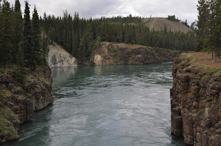
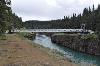
Just upstream of town is Miles Canyon.  Today its a placid stream flowing into a lake, but during gold rush days, the canyon was a torrent of rapids and whirlpools that destroyed many of the boats the miners used to float their supplies and equipment to Whitehorse.  Today there is a suspension bridge for foot traffic across the canyon and a great network of trails to hike.  I took advantage of two nice afternoons to cross the canyon and hike along it as well as hiking up into the woods towards the mountains.  Very refreshing after days of driving all day.

The trails are very well marked and are wide corridors through the trees.  I was impressed with them.  I met people running along the canyon's edge, others bicycling through the trees and hiking like me.   After looking over some of the trail map signs, I realized that it didn't end with winter.  They also used the trails for cross country skiing.  Now I begin to envy them.

Since its still springtime up here, the spring and early flowers are blooming.  I found this grove of aspen trees with blue Astilbe growing among them.  If this is like New Mexico, the wet spring months produce a riot of flowers that disappear as the days warm up and the rainfall drops.   Pat and I hiked to Mora Flats in the Pecos Wilderness early one summer and endured days of rains and repeated soakings.  Our reward was seeing the valley so covered in flowers you could not walk between them.  Many times I have been up there later in the year when there was no evidence that a flower had ever grown there.  Just grass.


And if you really want to, you can drive ten miles...oops 13km...to have a really good latte and a cheese sandwich in a coffee house buried in the woods.

Thursday, June 11, 2015

But, the sun is still up!

As we go farther north, a strange thing has happened. The sunset has kept getting later and later. We are at the summer solstice, so the days are reaching their greatest length. Last night the sun was still shining in my face as I yawned and thought I was really getting sleepy. It was 10:30 in the evening. It feels like when I was a kid and had to go to sleep before sunset in the summer. I hated that.  I think this will continue as we get further north. 

We are thinking about driving to the artic circle to see what its like and just to say we did it. However, its a three day trip of 1000 miles on a gravel road. I dunno, that's a lot of driving.

UPDATE:
Yep, it gets worst the further north you go.  Now its not dark in the middle of the night.

Critter count

Stone Goat
OK, so we have seen creatures along the road. Here is the score so far:

8-10 Stone Goats

4 Bighorn Sheep

Innumerable Pikas

8 Buffalo 

2 Bear


1 Elk

1 Caribou

No Moose

Today we are going to a wildlife refuge to see what we can find.  Hopefully the critter count changes.
Carabou


UPDATE:  NO such luck,  a tourist trap.  You couldn't frame a picture that didn't have barbed wire in it and they wanted money for this!

At last the Alaska Highway!

Original Milepost Zero Monument,
downtown Dawson's Creek
Dawson Creek  is the beginning of the Alaska Highway.  We stayed at an RV park named Mile 0 and it was the actual beginning.  The picture on the right is located downtown where the first surveyor set up his transit and pointed it north, so they say.

On the Alaskan Highway at last. After months of planning, working, rearranging schedules, we are actually here with our tires on this fabled highway. It seems magical and at the same time, oddly prosaic. After all, its just a two lane highway through pine trees. Hang onto that thought...a two lane highway through pine trees. It's a recurring theme for the next, say, thousand miles. However, all you have to do is look out the side window to realize that this highway is a very narrow corridor through an incredible wilderness that ends at the Bearing Sea.

The highway is surprisingly good. Much of it is as good as the roads around home and better than some. There have been the occasional construction sites that cause delays and an occasional really rough spot in the pavement. The speed limit is about 65 mph much of the way, but the Canadians never miss an opportunity to drop the speed limit 20 kph for anything along the side of the road. They do have a lot of bridges over rivers that are a bazillion feet below you when you are on the bridge. Many of these have steel mesh decks which make the RV squirrel around as it travels. The really interesting bridges are those with no shoulder and all the support structure below the bridge. A flat surface hanging in mid air with a few feet of lightweight guard rail. That will slow you down in a hurry as the rail disappears from view alongside the RV! See Pat scream!

But, you cannot travel this road without feeling its history. We have nice summer days with temperatures suitable for short-sleeved shirts and cool nights that are great for sleeping. Winters must really be something else. The low temperatures can reach -70F, a temperature that makes steel so brittle that it snaps. Eight feet of snow is a light snow cover, yet they keep the highway open.

The highway was begun as a joint Canadian, US military effort after Pearl Harbor forced people to reconsider the vulnerability of North America. Back then, Dawson Creek, BC was the end of the line; railroad that is. It was a small agricultural community. In 1942 the highway was begun there and finished in 1943 after 8 months and 12 days. In that time 27000 people built 1523 miles of highway, 133 bridges, some of which were washed out multiple times, and put in 8000 culverts. There were 7000 pieces of equipment that could not be shut down in the winter because they would not restart. In the summer, mosquitoes and black flies were so bad that people wore netting all the time. Bridges were built of wooden beams and only one of them is left standing.

We traveled from Dawson Creek, BC to Fort Nelson the first day on the highway. stopping to spend the night at the Triple G Hideaway, a colorful place and a nice evening. The next day we traveled to Watson's Lake, climbing over the Rockies again and re-crossing the continental divide. A good bit of this road was slow going over mountain passes and up steep grades. It's a shame to say, but you can become immune to the endless beauty of this place...look another beautiful blue lake against a snow capped mountain. We ate lunch at a turn out off the road at Muncho Lake (yeah, yeah no pun intended). PHOTO

We crossed into the Yukon Territory late in the afternoon. The Yukon! shades of all the stories and poems that I have read in school or for fun! Aha, a two lane highway between the pine trees (or more accurately spruce trees with some pines). At Watson's Lake we stayed at a less than beautiful RV park, imagine a gravel pit with rvs parked as closely as possible, but we slept. Should you ever get there, they have a planetarium there where they show you what the northern lights are all about. That is so definitely worth it. We learned a lot and saw light displays that were the result of a year of travel all over the world to places above the artic circle. Imagine filming in those -50 to -70F temperatures.

Leaving Watson's Lake we traveled to Whitehorse, YT. Another fabled place. The last gold rush came up from Fairbanks, Alaska on the Pacific coast and traveled up the Yukon River to get to Dawson City and the gold fields. The hallmark of this part of the trip is the amazing mountain lakes that go for miles and miles. Not just one of them, but you no sooner clear one than in a few minutes you are looking at another. There is so much water up here that I cannot believe that people have fished all of it. We crossed over so many beautiful streams and small rivers, each of which could have provided fishing for days.

The last several days have been long drives between distant towns over the type of road that keeps you busy driving. So we are taking a couple of days off in Whitehorse.

Sunday, June 7, 2015

From Jasper to Dawson Creek

Jasper to Prince George, BC

We left Jasper headed West on Canada 16.  As you go west, you gradually leave the mountains along a wide valley full of ranchland and farm fields.  The mountains are organized along southeast to northwest lines, so you cross an occasional ridge.  So you gradually come down out of the high country, but every time you say to yourself "We are getting out of the mountains", you round a corner and there is another snow capped peak.  Finally you leave Alberta and enter British Columbia.  In a few miles, there is an information center and Mt. Robeson, WOW.  Continuing down the highway, you come to ranch land and farm land that is very green and pretty.  Never mind that winter produces eight feet of snow and -40 F weather.  Right now its great. 

As we drove along, looking for the mythical Moose (that Glenn promises me has eaten a few International bumpers), we saw a brown bear.  He went by too fast to get a picture.  He was just sitting alongside the road in a very relaxed posture taking the sun.  "You know, Martha, I am going down to the highway and count tourists."  Either that or he was a Mountie in a ghillie suit. 

In Prince George we stayed at the Hartway RV park.  One great thing about Canada is that they have A&W Root Beer stands.  As my brother, George, will remember, they are special places.  If we were really good little boys for a long time, Mom would take us to A&W and get us a root beer float, a big one!  Well, George there was a stand at the turn off to the RV park and I had a root beer float for old times sake.  They are still delicious.

I really enjoy the Canadians.  They are easy to meet and fun to talk to.  I helped the gentleman next to us move a picnic table around where he needed it.  We chatted several times that evening and the next day.  He told me that he lived along the Alaska Highway, and where to stop to get really good sourdough bread and sticky buns. The whole time he had a look on his face like an eight year old boy looking into the display counter in the bakery.  He promised me that you had to get to the Yukon to get good sourdough, they didn't know how to make it here.  He also told me to go to Chicken, Alaska to pan for gold. He said he always kept a pan handy.  Well, who could ignore a place named Chicken.  He said there actually are two Chickens.  The old one is quaint, and the newer one, ordinary.  We'll see.  Cid, the owner of the RV park sent us down the road to eat at the Alpine Inn, recommending the Friday special of fish and chips.  Delicious.  Folks at the table next to us asked where we were from and explained that they had moved to BC a little while ago from Nova Scotia.  They made us promise to go to Nova Scotia on another epic adventure and extolled the variety of climates and environments there.  Their opinion was the BC was nothing but trees.  They had a point.

Chetwynd, BC 

About 45 miles west of Dawson Creek we came to the town of Chetwynd, BC.  Winters there must be really long, because the town is lined with chainsaw carvings done from logs.  But they are really really well done.  Here are some pictures.  These should inspire Glenn..Mindi, don't let him near the tree in your front yard!  They also have an A&W Root Beer stand, another root beer float....eat your heart out, George!

From there its on to Dawson Creek and the Alaska Highway.


Does the moose really exist?

Methinks not!

For at least 7 days I have been driving by signs with a silhouette of an animal called MOOSE and warning me not to hit it.  Sometimes these are accompanied by speed limits of 25-30 mph along a deserted highway with nothing moving other than us, silly!  Some of these signs have been as big as our RV, surrounded by reflective stripes and promising sudden death.  So far, no animals.

This is consistent with my experience in Maine.  All signs, all promises, no moose.  The only one I have seen in Maine is compliments of John Hinz who was kind enough to turn around in the middle of the road and take me back to where he saw one.  I still owe him for that kindness.  What was there was a silhouette cut from plywood and painted black. 

Perhaps the moose is really a black shadow that exists on boards.

North across the Canadian Rockies

June 4, 2015  We left Lake Louise this morning and turned up Highway 93 into the Banff National park.  It is one of four connected parks.  They are Kootany, Yoho, and Jasper National Parks. 

It had been raining and drizzling for the past several days.  Its been dry here so the rain is welcome,  but louses up sightseeing to some extent.  However, today its sunny with beautiful clouds above the mountains.  The highway goes through high moraine valleys with amazing mountain peaks on each side.  It is surprisingly easy driving; a wide two lane road with reasonably gentle grades.  It does go up in altitude but not like a lot of the roads through the mountains in Colorado.   Red rock pass in Colorado is stuck in my mind!  Everything that has been said about these mountains is true.  They are amazing.  Here are a few illustrations:


The mountain ranges seem arranged differently than what I am accustomed to.  They seem to be long relatively continuous chains of peaks with valleys between them.  Perhaps if you got off the highway and could go east-west you would find the clusters of peaks that you see in Colorado.  In a few places you can see up side valleys where the peaks seem to be organized like the Colorado mountains.
 
That being said, there is one really spectacular climb up above timber line.  Here is a picture looking south in the direction from which we came.  Here it was rainy and so the distance is somewhat obscured.  The dot on the highway is a truck.  One thing that is true of western Canada is that there is no shortage of conifers.  There are endless forests here and I cannot imagine how much of this land never sees a human. 


 No sooner than we had leveled out from the climb than everything came to a screeching halt.  Here is the reason for the stop.  Two Stone Goats were busy licking something out of the cracks in the road.  They knew who owned the road and even our RV wouldn't move them.  They finally moved to the shoulder and I got by, but they came right back into the road behind me.


After you go over this pass, the road stays high and you come to the area that gives the highway its name, Icefields Highway. This is one leg of a glacier that comes over at least three other saddles down towards the road.  Just at the skyline in this picture you can see the main ice field that stretches back into the mountains for a long way.  There are two busses on the left central part of the ice field and at least two parties of hikers going up the middle of the ice field.  For a small fee of $54 each,  you can ride the bus out onto the ice.  Considering how much time I spend on ice and snow, we declined.  The grey stuff on the sides and bottom of the glacier is material dropped by the last ice age glaciers.


Jasper, AB.   Whistler Campground

The Jasper National Park is the northern third of the trip through the mountains.  The town of Jasper is a really nice thriving community that is surprisingly full of places to meet a tourist's needs.  Whistler is a National Park campground just south of town.  So we found that the cow Elk were calving, the Grizzly bears were trying to eat the newborn elk and the Park Rangers were really nervous.  They were going around telling people to stay away from the animals so they wouldn't get trampled like the lady last week.


 We got the campground in the very back of the place.  The next morning nothing was dead, no tourists trampled and the rangers were still nervous.