Thursday, June 11, 2015

At last the Alaska Highway!

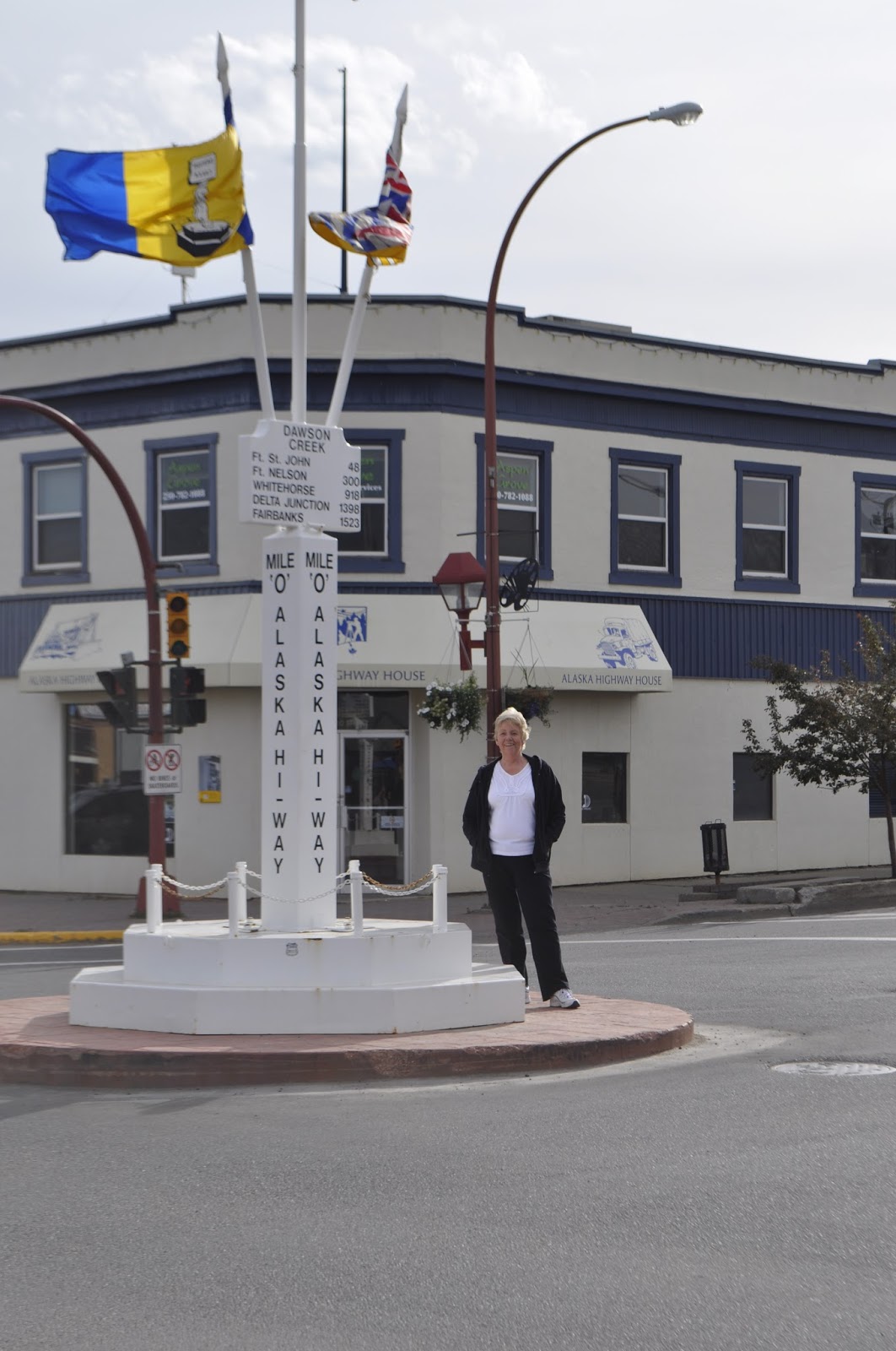
Original Milepost Zero Monument,
downtown Dawson's Creek
Dawson Creek  is the beginning of the Alaska Highway.  We stayed at an RV park named Mile 0 and it was the actual beginning.  The picture on the right is located downtown where the first surveyor set up his transit and pointed it north, so they say.

On the Alaskan Highway at last. After months of planning, working, rearranging schedules, we are actually here with our tires on this fabled highway. It seems magical and at the same time, oddly prosaic. After all, its just a two lane highway through pine trees. Hang onto that thought...a two lane highway through pine trees. It's a recurring theme for the next, say, thousand miles. However, all you have to do is look out the side window to realize that this highway is a very narrow corridor through an incredible wilderness that ends at the Bearing Sea.

The highway is surprisingly good. Much of it is as good as the roads around home and better than some. There have been the occasional construction sites that cause delays and an occasional really rough spot in the pavement. The speed limit is about 65 mph much of the way, but the Canadians never miss an opportunity to drop the speed limit 20 kph for anything along the side of the road. They do have a lot of bridges over rivers that are a bazillion feet below you when you are on the bridge. Many of these have steel mesh decks which make the RV squirrel around as it travels. The really interesting bridges are those with no shoulder and all the support structure below the bridge. A flat surface hanging in mid air with a few feet of lightweight guard rail. That will slow you down in a hurry as the rail disappears from view alongside the RV! See Pat scream!

But, you cannot travel this road without feeling its history. We have nice summer days with temperatures suitable for short-sleeved shirts and cool nights that are great for sleeping. Winters must really be something else. The low temperatures can reach -70F, a temperature that makes steel so brittle that it snaps. Eight feet of snow is a light snow cover, yet they keep the highway open.

The highway was begun as a joint Canadian, US military effort after Pearl Harbor forced people to reconsider the vulnerability of North America. Back then, Dawson Creek, BC was the end of the line; railroad that is. It was a small agricultural community. In 1942 the highway was begun there and finished in 1943 after 8 months and 12 days. In that time 27000 people built 1523 miles of highway, 133 bridges, some of which were washed out multiple times, and put in 8000 culverts. There were 7000 pieces of equipment that could not be shut down in the winter because they would not restart. In the summer, mosquitoes and black flies were so bad that people wore netting all the time. Bridges were built of wooden beams and only one of them is left standing.

We traveled from Dawson Creek, BC to Fort Nelson the first day on the highway. stopping to spend the night at the Triple G Hideaway, a colorful place and a nice evening. The next day we traveled to Watson's Lake, climbing over the Rockies again and re-crossing the continental divide. A good bit of this road was slow going over mountain passes and up steep grades. It's a shame to say, but you can become immune to the endless beauty of this place...look another beautiful blue lake against a snow capped mountain. We ate lunch at a turn out off the road at Muncho Lake (yeah, yeah no pun intended). PHOTO

We crossed into the Yukon Territory late in the afternoon. The Yukon! shades of all the stories and poems that I have read in school or for fun! Aha, a two lane highway between the pine trees (or more accurately spruce trees with some pines). At Watson's Lake we stayed at a less than beautiful RV park, imagine a gravel pit with rvs parked as closely as possible, but we slept. Should you ever get there, they have a planetarium there where they show you what the northern lights are all about. That is so definitely worth it. We learned a lot and saw light displays that were the result of a year of travel all over the world to places above the artic circle. Imagine filming in those -50 to -70F temperatures.

Leaving Watson's Lake we traveled to Whitehorse, YT. Another fabled place. The last gold rush came up from Fairbanks, Alaska on the Pacific coast and traveled up the Yukon River to get to Dawson City and the gold fields. The hallmark of this part of the trip is the amazing mountain lakes that go for miles and miles. Not just one of them, but you no sooner clear one than in a few minutes you are looking at another. There is so much water up here that I cannot believe that people have fished all of it. We crossed over so many beautiful streams and small rivers, each of which could have provided fishing for days.

The last several days have been long drives between distant towns over the type of road that keeps you busy driving. So we are taking a couple of days off in Whitehorse.

Sunday, June 7, 2015

From Jasper to Dawson Creek

Jasper to Prince George, BC

We left Jasper headed West on Canada 16.  As you go west, you gradually leave the mountains along a wide valley full of ranchland and farm fields.  The mountains are organized along southeast to northwest lines, so you cross an occasional ridge.  So you gradually come down out of the high country, but every time you say to yourself "We are getting out of the mountains", you round a corner and there is another snow capped peak.  Finally you leave Alberta and enter British Columbia.  In a few miles, there is an information center and Mt. Robeson, WOW.  Continuing down the highway, you come to ranch land and farm land that is very green and pretty.  Never mind that winter produces eight feet of snow and -40 F weather.  Right now its great. 

As we drove along, looking for the mythical Moose (that Glenn promises me has eaten a few International bumpers), we saw a brown bear.  He went by too fast to get a picture.  He was just sitting alongside the road in a very relaxed posture taking the sun.  "You know, Martha, I am going down to the highway and count tourists."  Either that or he was a Mountie in a ghillie suit. 

In Prince George we stayed at the Hartway RV park.  One great thing about Canada is that they have A&W Root Beer stands.  As my brother, George, will remember, they are special places.  If we were really good little boys for a long time, Mom would take us to A&W and get us a root beer float, a big one!  Well, George there was a stand at the turn off to the RV park and I had a root beer float for old times sake.  They are still delicious.

I really enjoy the Canadians.  They are easy to meet and fun to talk to.  I helped the gentleman next to us move a picnic table around where he needed it.  We chatted several times that evening and the next day.  He told me that he lived along the Alaska Highway, and where to stop to get really good sourdough bread and sticky buns. The whole time he had a look on his face like an eight year old boy looking into the display counter in the bakery.  He promised me that you had to get to the Yukon to get good sourdough, they didn't know how to make it here.  He also told me to go to Chicken, Alaska to pan for gold. He said he always kept a pan handy.  Well, who could ignore a place named Chicken.  He said there actually are two Chickens.  The old one is quaint, and the newer one, ordinary.  We'll see.  Cid, the owner of the RV park sent us down the road to eat at the Alpine Inn, recommending the Friday special of fish and chips.  Delicious.  Folks at the table next to us asked where we were from and explained that they had moved to BC a little while ago from Nova Scotia.  They made us promise to go to Nova Scotia on another epic adventure and extolled the variety of climates and environments there.  Their opinion was the BC was nothing but trees.  They had a point.

Chetwynd, BC 

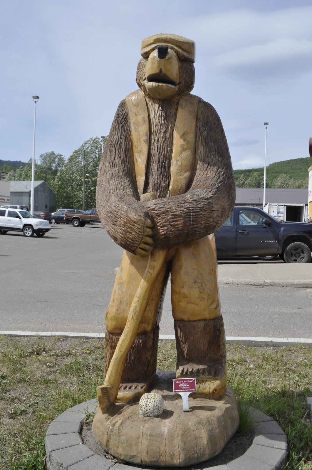
About 45 miles west of Dawson Creek we came to the town of Chetwynd, BC.  Winters there must be really long, because the town is lined with chainsaw carvings done from logs.  But they are really really well done.  Here are some pictures.  These should inspire Glenn..Mindi, don't let him near the tree in your front yard!  They also have an A&W Root Beer stand, another root beer float....eat your heart out, George!

From there its on to Dawson Creek and the Alaska Highway.


Does the moose really exist?

Methinks not!

For at least 7 days I have been driving by signs with a silhouette of an animal called MOOSE and warning me not to hit it.  Sometimes these are accompanied by speed limits of 25-30 mph along a deserted highway with nothing moving other than us, silly!  Some of these signs have been as big as our RV, surrounded by reflective stripes and promising sudden death.  So far, no animals.

This is consistent with my experience in Maine.  All signs, all promises, no moose.  The only one I have seen in Maine is compliments of John Hinz who was kind enough to turn around in the middle of the road and take me back to where he saw one.  I still owe him for that kindness.  What was there was a silhouette cut from plywood and painted black. 

Perhaps the moose is really a black shadow that exists on boards.

North across the Canadian Rockies

June 4, 2015  We left Lake Louise this morning and turned up Highway 93 into the Banff National park.  It is one of four connected parks.  They are Kootany, Yoho, and Jasper National Parks. 

It had been raining and drizzling for the past several days.  Its been dry here so the rain is welcome,  but louses up sightseeing to some extent.  However, today its sunny with beautiful clouds above the mountains.  The highway goes through high moraine valleys with amazing mountain peaks on each side.  It is surprisingly easy driving; a wide two lane road with reasonably gentle grades.  It does go up in altitude but not like a lot of the roads through the mountains in Colorado.   Red rock pass in Colorado is stuck in my mind!  Everything that has been said about these mountains is true.  They are amazing.  Here are a few illustrations:


The mountain ranges seem arranged differently than what I am accustomed to.  They seem to be long relatively continuous chains of peaks with valleys between them.  Perhaps if you got off the highway and could go east-west you would find the clusters of peaks that you see in Colorado.  In a few places you can see up side valleys where the peaks seem to be organized like the Colorado mountains.
 
That being said, there is one really spectacular climb up above timber line.  Here is a picture looking south in the direction from which we came.  Here it was rainy and so the distance is somewhat obscured.  The dot on the highway is a truck.  One thing that is true of western Canada is that there is no shortage of conifers.  There are endless forests here and I cannot imagine how much of this land never sees a human. 


 No sooner than we had leveled out from the climb than everything came to a screeching halt.  Here is the reason for the stop.  Two Stone Goats were busy licking something out of the cracks in the road.  They knew who owned the road and even our RV wouldn't move them.  They finally moved to the shoulder and I got by, but they came right back into the road behind me.


After you go over this pass, the road stays high and you come to the area that gives the highway its name, Icefields Highway. This is one leg of a glacier that comes over at least three other saddles down towards the road.  Just at the skyline in this picture you can see the main ice field that stretches back into the mountains for a long way.  There are two busses on the left central part of the ice field and at least two parties of hikers going up the middle of the ice field.  For a small fee of $54 each,  you can ride the bus out onto the ice.  Considering how much time I spend on ice and snow, we declined.  The grey stuff on the sides and bottom of the glacier is material dropped by the last ice age glaciers.


Jasper, AB.   Whistler Campground

The Jasper National Park is the northern third of the trip through the mountains.  The town of Jasper is a really nice thriving community that is surprisingly full of places to meet a tourist's needs.  Whistler is a National Park campground just south of town.  So we found that the cow Elk were calving, the Grizzly bears were trying to eat the newborn elk and the Park Rangers were really nervous.  They were going around telling people to stay away from the animals so they wouldn't get trampled like the lady last week.


 We got the campground in the very back of the place.  The next morning nothing was dead, no tourists trampled and the rangers were still nervous.

Friday, June 5, 2015

At last, a map!

It really is useful to know where you are going when you are going to Alaska.  The Alaska part is easy, but the devil is in the details for sure.  So tonight the very nice people running the RV park, Hartway RV Park, in Prince George, BC, provided us with so much useful information about what is in front of us.  If you ever plan to do this, get the book:  The Milepost, Alaska Travel Planner, published by Morrison.  It gives you a world of information that is very well organized.  As the man says," Don't leave home without it!"

Playing catchup


So even in this day and age, traveling through the mountains does not allow good internet or cell phone connectivity. I for one am glad that there are still disconnected places on this earth even though I have missed all of you.  So here's the deal.  I have made notes of our trip since the last blog that I will put in here tonight since I have a good internet connection...Oh by the way we've made it to Prince George, British Columbia... and I will edit them as I can to include the pictures we've taken.

Beginning insertion:
May 30

We are at the Bow River Campground in Colchrane, AB. We are in need of a rest, so today is a no-travel day. We have done not much but rest, shop and have dinner in a nice Thai restaurant. I have been looking for maps of our route to Alaska since I am reluctant to throw caution to the winds and found them in a store called Canadian Tire, that sells everything from hocky sticks to motor oil (didn't see any tires, though). That may not sound exciting in a blog, but it was to the RV driver. Tomorrow, we will continue on our way to Banff National Park.

June 1

We started to leave Colchrane this morning, but could not get one of the towbar legs to latch, causing the truck to lurch towards the coach and veer to the right every time we slowed down. We found this out in a parking lot before we got on the road, so returned to the Bow River Campground for another night. I was able to disassemble the latch on the bad tow strut and found it full of grit. After cleaning it and reversing the latch spring for a better pull, it worked quite well. We continued our lazy ways until the next morning. 


Glenn and Stephen were right when they said to get all the tools you think you need then add more.  I would have never gotten the job done without a pair of tweezers!!

Since time was available, I set up the portable work table that was invented by Glenn Miller, Springfield's resident clever guy, and was able to spend some enjoyable time carving a piece of the cherry tree that smashed my truck a few years ago.


June 2

Today we continued on Canada highway 1, the trans-Cannada highway. It is a fine four lane divided highway that transects the Canadian Rockies at Banff National Park, runing along the Bow River Valley in a scenic drive past craggy mountains and a beautiful river.


 We reached Canmore, AB and stayed at the Spring Creek Mountain Village RV park. It rained all day long, making for wet work outside of the RV. The tow bar worked correctly today, what a relief, since had it not, we would have returned to Calgary to find a repair shop. Since Canmore is close to Colchrane, we had much of the day for sight seeing. We drove to Banff and looked around the town and the Bow River falls.


Cute Lady!


We continued to Lake Louise, a village at the entrance to the northern route through the park and the home of the famous Lake Louise Chalet. We found the information we needed to get campgrounds and travel north to Jasper, AB at the northern edge of the four parks that make up this portion of the Canadian Rockies. We returned to Canmore and spent the night.

June 3

Today we traveled to Lake Louise via highway 1-A, the scenic route through the park. It was great to be back in pine/spruce forests and among mountain rivers and lakes again. The day has been rainy again, limiting the amout of running around outside. This fellow was taking his rainy day easy off to the side of the road and causing a respectable traffic jam while the rubber-neckers (me included) took pictures.

After checking into a park service campground, we set off to see some famous sights.    We went to Lake Louise, a few miles south of the town up a steep mountain road and visited both the lake and hotel.  Lake Louise is a beautiful sight with an amazing hotel built on its shore, Chateau Lake Louise.
Chateau Lake Louise

Lake Louise
Moraine Lake


We also went to Moraine Lake, a cirque lake 15 km away from town.


So today is our 25th wedding anniversary and we celebrated with dinner at the dining room in the Lake Louise Chalet. What a great venue. 


  What wonderful 25 years. A great way to spend our anniversary day.


Saturday, May 30, 2015

West of Calgary, Alberta

Tonight we are in a campground with internet service, so I can share today's adventures.  No pictures, though.

Well, this morning we left Cut Bank, a really small town in northern Montanna, drove west to Browning, then north, The trip north on US 89 was terrible.  About 25 miles of the road was under construction, which consisted of rubblising both lanes and digging up the shoulder.  I drove down the middle of the road, moving over and slowing to a crawl when we met oncoming vehicles.  Fortunately, there were very few of those.  There was no place to turn around, so I had no choice but to keep going.  When we got past the construction, we ended up on a mountain road on the east side of Glacer National Park that was full of 15-20 mph turns, so it was slow going.  The plus was some beautiful scenery.  A picture or two later.  

We crossed the border into Canada and continued north.  Now it really feels like an adventure!  By this time we were back in the plains, green grass and Canadian ranches.  Although it was rainy and cloudy in Montanna, the weather cleared the farther north we went.  By the time we reached Calgary, it was sunny and warm.  We got to Calgary just about rush hour.  Canadian rush hour has just about as much to recommend it as does the US version..not much!  

We went west from Calgary to Cochrane, Alberta, which is on the road to Banff.  We are at a very nice campground.  We are going to spend tonight and tomorrow here getting some rest.  Then we are going to Banff.  I have wanted to see that for decades, hurray!

By the way, two days ago we stopped at a rest area to stretch our legs.  The fellow from a camper two spaces down from us came over to find out if we were going into Canada.  We shared what we knew and chatted for a while.  He was from Rapid City ans was named Jim.  He is on his way to Alaska also, but by a somewhat different route than us.  However before you get there, there is only one route.  We agreed to be on the lookout for each other.  An example of a small world, eh, Brian?  I mentioned you to him, but he only knew of the Presbyterian church in the center of town.